Richmond Is Growing West:
The Roads, Development & Infrastructure Reshaping Chesterfield.

By Tamara Totman, REALTOR® | Totman Real Estate | November 1, 2026
If you have driven through western Chesterfield lately, you have probably felt it before you ever looked at a planning map: more construction, more rooftops, more road work and more signs that the center of gravity is shifting west. What is happening around Route 288, Powhite Parkway, Woolridge Road, Genito Road and Hull Street is not one project. It is a network of transportation, housing, employment and commercial investments that will change how this part of the Richmond region functions.
For homeowners and buyers, the useful question is not simply whether growth is “good” or “bad.” The better questions are: Which projects are actually funded? Which are under construction? Which are still studies? How could they change access, traffic, nearby land use and future buyer demand? And what should you verify before paying a premium for a future amenity or road connection?
The short version: western Chesterfield is receiving unusually large transportation and development investment, but the value is in understanding the exact stage and location of each project — not assuming every announcement will raise nearby home values.
1. Powhite Parkway is no longer just a dotted line
on a map.

The Powhite Parkway extension has been discussed for decades, but Phase I is now moving toward physical construction. Chesterfield County says the first phase is a fully funded $150 million project that will extend the existing four-lane roadway from its current terminus to Woolridge Road. The county advertised construction in 2026, with physical work expected to begin in late 2026 or early 2027 and continue through 2029.
Phase I is not a single straight road project. It includes several coordinated pieces: a high-capacity intersection at Woolridge Road, bridges over Tomahawk Creek, a Watermill Parkway overpass, improvements near Brandermill Parkway and Charter Colony, and a shared-use path. That matters because access around Brandermill, Watermill, RounTrey and the Route 288 corridor will be reconfigured as the network is completed.
The larger vision reaches much farther. In September 2026, Chesterfield reported that it had secured almost $300 million toward an estimated $565 million, roughly 9.2-mile extension toward Route 360. The county said that if remaining funding is secured, a two-lane restricted-access connection could reach Route 360 by 2034, with the corridor graded so it can be widened later. That is meaningful progress — but it is still a future project with funding and environmental/project-development steps remaining.
Another practical change: Chesterfield reported that VDOT plans to remove the 75-cent Powhite Parkway toll at Courthouse Road in January 2027. For people who already use Powhite regularly, that is a much nearer-term change than the full western extension.
2. Woolridge Road is becoming a major
transportation spine.
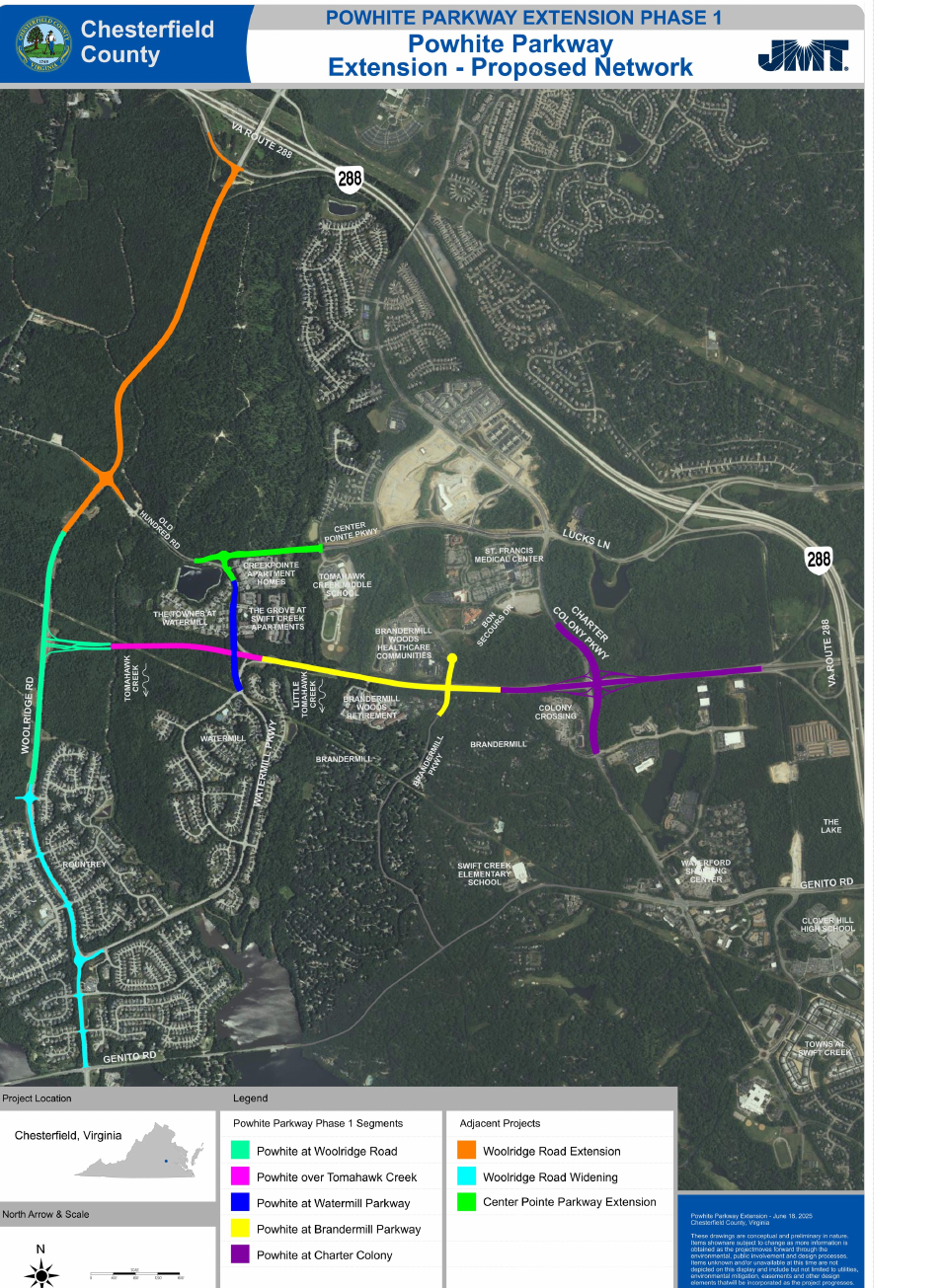
Woolridge Road is one of the most important pieces of this puzzle because several projects converge there. The extension from Old Hundred Road to Route 288 is already under construction. Chesterfield awarded a $41.9 million contract for approximately 1.25 miles of new four-lane divided roadway, including a bridge over Tomahawk Creek, pedestrian facilities, signal work at the Route 288 ramps and a hybrid roundabout at Old Hundred Road. Construction began in December 2025.
South of that extension, the county is also preparing to widen Woolridge Road from the Watermill Parkway area to Genito Road. Right-of-way acquisition is complete, utility relocations are underway, and the county currently schedules construction from early 2027 through September 2029.
Taken together with Powhite, Woolridge starts to function less like a local road and more like a north-south connector between Route 288, Old Hundred, Watermill, Genito and the neighborhoods growing around them. That can be a positive accessibility story for some properties — while homes directly affected by construction, new intersections or widened road frontage may experience the transition very differently.
3. Center Pointe and Bailey Bridge add redundancy — which matters more than it sounds.
Two other projects deserve attention because they create alternative ways through a road network that has long funneled too much traffic toward a limited number of major intersections.
The Center Pointe Parkway Extension is under construction. The contractor mobilized in August 2026, with substantial completion targeted for August 2027. The project extends Center Pointe from Tomahawk Creek Road to Old Hundred Road and eventually supports a more direct connection toward St. Francis Medical Center, Lucks Lane, Charter Colony and Route 288.
South of Hull Street Road, the $28.5 million Bailey Bridge Connector is also under construction. Chesterfield has described it as a way for residents south of Route 360 to bypass the heavily traveled Route 288/360 interchange during peak commuting periods. These projects may not generate the same headlines as Powhite, but network redundancy often has an outsized effect on day-to-day driving.
4. Genito Road and Route 288 are still a watch area — not a promise.
Genito Road is where several growth stories collide: The Lake, River City Sportsplex, existing neighborhoods, future residential development and the Route 288 corridor. Chesterfield has completed a Genito Road corridor study between Woolridge Road and the Charter Colony/Old Hundred area; as of late October 2026, it was complete and pending VDOT approval.
The county is also finalizing a Route 288 corridor study between Powhite Parkway and Hull Street Road. One of the questions being evaluated is whether an interchange at Genito Road and Route 288 is feasible. That distinction is important: an interchange is being studied; it is not the same thing as a funded, approved interchange ready for construction.
For buyers, this is exactly the kind of nuance that matters. A future access point can sound attractive in a sales conversation, but the responsible way to evaluate a property is to price it based on today’s access while treating an unfunded or unapproved future connection as a possibility, not a certainty.
5. The Lake is still part of the Genito story — but separate the vision from delivery.
The Lake, near Genito Road and Route 288, has been envisioned as a major 105-acre mixed-use and recreation-oriented development. A March 2026 U.S. Army Corps of Engineers public notice described proposed completion work that includes recreational areas, retail, townhomes, multifamily apartments, roads, utilities and stormwater facilities.
The important real-estate lesson is not to treat a rendering or long-range master plan as a delivered amenity. Large mixed-use projects can change phases, financing, timing and components over many years. The Lake remains a meaningful development node to watch because of its location and planned scale, but homeowners and buyers should distinguish what is open today from what is approved, permitted, under construction or still proposed.
That does not make the project irrelevant. Even before every planned entertainment component is delivered, road improvements, commercial activity and new residential construction around the site can influence traffic patterns and how buyers perceive the Genito/288 area.
6. Upper Magnolia Green could reshape the western Route 360 corridor.
Upper Magnolia Green is one of the largest long-term land-use stories in Chesterfield. The county acquired roughly 2,057 acres in 2020. About 1,700 acres west of the planned Powhite corridor were rezoned for an employment-focused technology village, while land to the east was planned for public facilities, including schools and a library.
In 2026, Chesterfield announced $45 million in state and federal funding to begin construction of the Western Area Arterial Collector from Route 360 toward Upper Magnolia Green West. The roadway is intended to become part of the broader Powhite corridor and is another reason the western Route 360 area should be evaluated as a changing system rather than a collection of isolated subdivisions.
For nearby homeowners, this is a two-sided story. New employment investment and infrastructure can improve regional connectivity and strengthen the commercial tax base. At the parcel level, however, future roads, technology uses, utility infrastructure and traffic can affect different properties in different ways.
7. Data centers are part of the land-use picture, especially at Upper Magnolia Green and Watkins Centre.
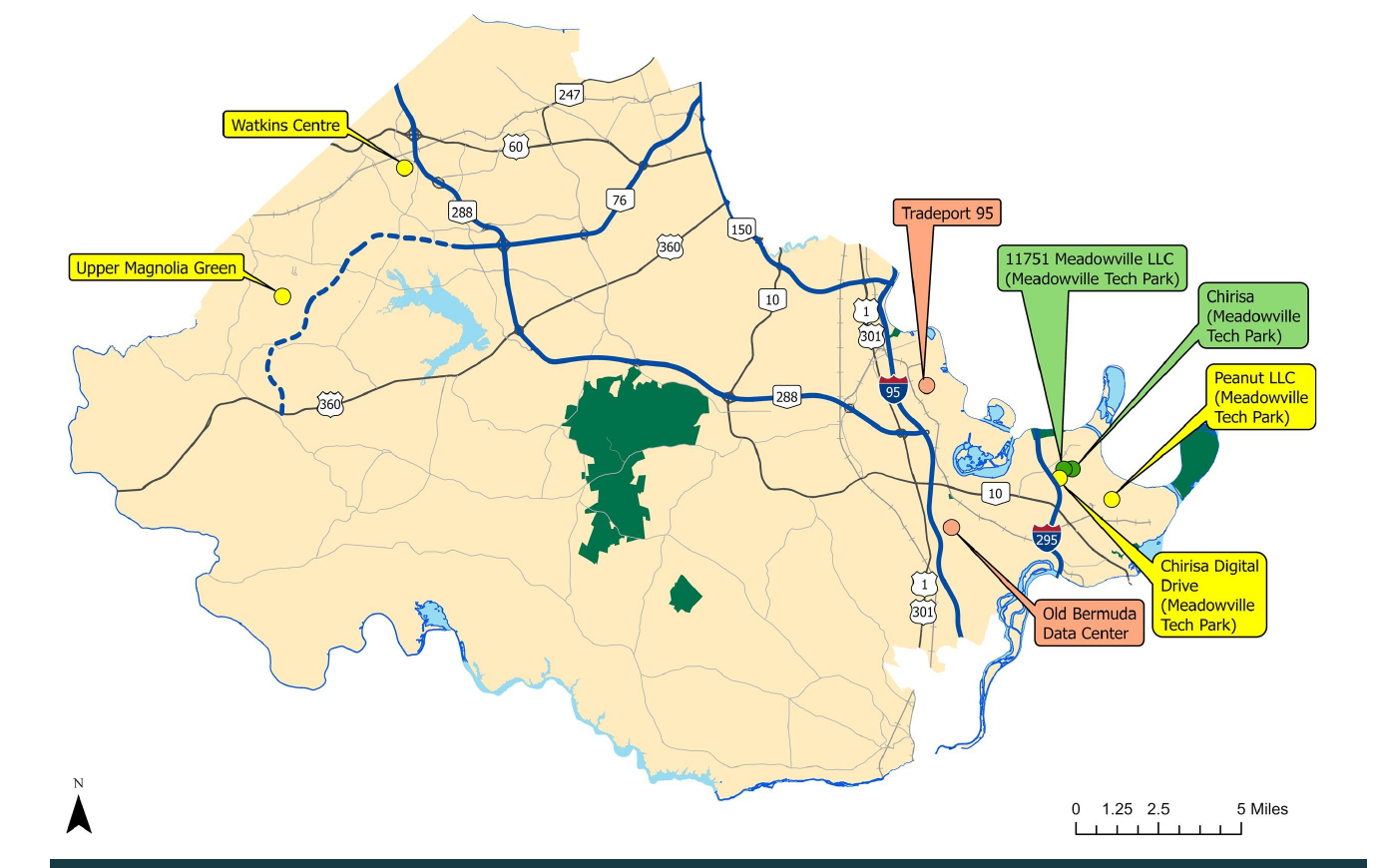
Chesterfield’s July 2026 inventory shows two approved future data-center sites on the western side of the county: Upper Magnolia Green at 4201 Moseley Road and Watkins Centre at 750 Watkins Centre Parkway. Both have zoning approval; the number of buildings was not specified in the county’s July status table.
The county has adopted conditions addressing issues such as buffers, noise and water use. Upper Magnolia Green includes a minimum 200-foot variable-width buffer, with a 750-foot setback in certain areas adjacent to single-family homes along Moseley Road. Watkins Centre has a minimum 100-foot buffer.
This is not a reason to declare every nearby property a winner or loser. It is a reason to do property-level due diligence. Buyers should understand exact distance, topography, road access, transmission infrastructure, buffers and what can actually be seen or heard from the property — rather than relying on the subdivision name alone.
What does all of this mean for Richmond-area real estate?
Infrastructure can change real-estate behavior because it changes friction. A home that feels far from a job center, school, shopping or regional highway today may feel different after a new connection opens. New restaurants, employment centers and services can make an outer-suburban location more convenient. But construction can also bring years of detours, noise, changed traffic patterns and new land uses that some buyers will dislike.
For buyers, I would ask:
- What is actually funded and under construction — versus simply planned or studied?
- How will the exact property access change when the road project is complete?
- What is planned for nearby vacant land, and what zoning has already been approved?
- Could a widened road, interchange, data center, utility corridor or commercial site affect the view, noise or traffic?
- Are you paying a premium today for an amenity or commute improvement that may take years to arrive?
- How does the total price compare with an established resale neighborhood where the access and amenities already exist?
For homeowners, I would watch:
- Construction and opening milestones, not just announcements.
- Changes to traffic flow and access points near the neighborhood.
- New commercial and employment uses that could change buyer perception of the area.
- Nearby zoning cases and infrastructure plans before making major renovation, move or rental decisions.
Growth is not the only real-estate advantage.
There is an equally important counter-story in Richmond’s established neighborhoods. Areas such as the Near West End, Westhampton, Bon Air, established Midlothian and other mature locations have something a growth corridor cannot manufacture quickly: existing character, mature trees, established amenities, proven access and limited opportunities to create more of the same housing in the same location.
Western Chesterfield is a story of change, connectivity and future development. Established Richmond-area neighborhoods are often a story of scarcity and what is already there. Neither is automatically better. The smart decision depends on the individual property, the buyer’s priorities, the price and how much uncertainty they are comfortable owning.
The map is changing — and the listing rarely tells you the whole story.
The biggest takeaway is simple: when you buy a home, you are also buying into a road network, a land-use plan and a future version of the surrounding community. Richmond’s southwest growth corridor is one of the clearest places to see that happening in real time.
That is why I like to look beyond the listing itself. A beautiful kitchen matters. So do the road planned behind the neighborhood, the commercial site down the street, the new bridge, the zoning case and the commute that may look very different five years from now.
If you are considering a home in Chesterfield, Midlothian, Moseley or another Richmond-area growth corridor, I am happy to help you look at both the house you are buying and what is happening around it.
Tamara Totman, REALTOR®
Totman Real Estate
Richmond-area residential real estate • 760-707-7411 • TotmanRealEstate.com
Note: Project status, funding, schedules, zoning and development plans can change. This article is for general real-estate education and planning, not a guarantee of future appreciation or a substitute for property-specific due diligence. Information updated October 31, 2026.
Sources & Verification Links.
- Chesterfield County — Powhite Parkway Extension — Phase I/Phase II structure and project components.
- Chesterfield County — “Legend No Longer” Transportation Update (September 8, 2026) — Funding, costs, 2029 targets, Phase II planning, Bailey Bridge Connector and toll-removal update.
- Chesterfield County — Woolridge Road Extension — Construction began December 2025; extension to Route 288.
- Chesterfield County — Woolridge Road Widening — Utility relocation and 2027–2029 construction schedule.
- Chesterfield County — Center Pointe Parkway Extension — Contractor mobilized August 2026; 2027 completion targets.
- Chesterfield County — Route 288 Corridor Study — Genito/288 interchange feasibility is being studied.
- Chesterfield County — Genito Road Corridor Study — Study complete and pending VDOT approval as of late October 2026.
- U.S. Army Corps of Engineers — The Lake Public Notice (March 2, 2026) — Proposed mixed-use completion work.
- Chesterfield County — Upper Magnolia Green Overview — County acquisition, technology-village plan and infrastructure context.
- Chesterfield County — Data Centers — July 2026 status, Upper Magnolia Green/Watkins Centre approvals, buffers and water-use information.